Collection: Comparative Maps - Antique
Comparative maps were popular in the mid to late 1800s when Europeans felt they knew almost all there was to know about the world. They compiled the information into these stunning info graphics that we call comparative maps or charts. Sometimes they later learned that they were missing something!
-
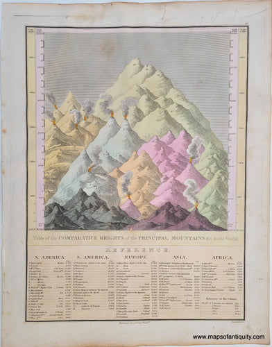
1824 - Table of the Comparative Heights of the Principal Mountains in the World. - Antique Map
![Antique-Hand-Colored-Map-Table-of-the-Comparative-Heights-of-the-Principal-Mountains-in-the-World.-Comparative-Maps--1824-Anthony-Finley-Maps-Of-Antiquity]()
- Regular price
- $250.00
- Sale price
- $250.00
- Regular price
-
- Unit price
- per
Sold out -
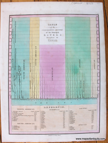
1826 - Table of the Comparative Lengths of the Principal Rivers throughout the World. - Antique Map
![Antique-Map-Table-of-the-Comparative-Lengths-of-the-Principal-Rivers-throughout-the-World.]()
- Regular price
- $150.00
- Sale price
- $150.00
- Regular price
-
- Unit price
- per
Sold out -
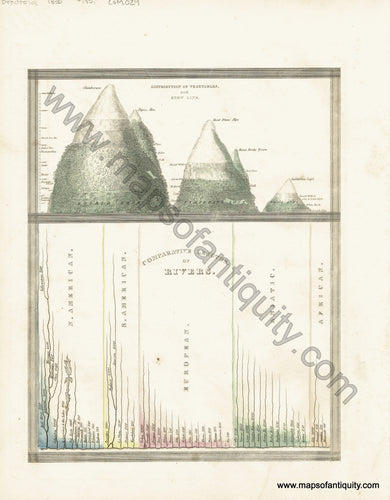
1827 - Map and Description of the Principal Mountains, &c. Throughout the World. - Antique Chart
![Antique-Map-and-Description-of-the-Principal-Mountains-&c.-Throughout-the-World]()

- Regular price
- $200.00
- Sale price
- $200.00
- Regular price
-
- Unit price
- per
Sold out -
1830 - A Chart Exhibiting the Comparative Size, Population, form of Government, and number of Square Miles in each of the principal Empires, Kingdoms... - Antique Map
![Genuine-Antique-Comparative-Chart-A-Chart-Exhibiting-the-Comparative-Size,-Population,-form-of-Government,-and-number-of-Square-Miles-in-each-of-the-principal-Empires,-Kingdoms,-&c-of-the-Globe,-also-the-manner-of-building-among-different-Nations-according-to-their-Civilization.-1830-E.-Huntington-/-D.F.-Robinson-&-Co.-Maps-Of-Antiquity]()

- Regular price
- $50.00
- Sale price
- $50.00
- Regular price
-
- Unit price
- per
Sold out -
1835 - Comparative Lengths of Rivers - Antique Map
![Antique-Hand-Colored-Map-Comparative-Lengths-of-Rivers-Comparative-Maps--1835-T.G.-Bradford-Maps-Of-Antiquity]()
- Regular price
- $175.00
- Sale price
- $175.00
- Regular price
-
- Unit price
- per
Sold out -
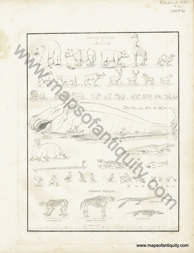
1835 - Comparative Size of Animals - Antique Map
![Antique-Hand-Black-and-White-Map-Comparative-Size-of-Animals-Comparative-Maps--1835-T.G.-Bradford-Maps-Of-Antiquity]()
- Regular price
- $50.00
- Sale price
- $50.00
- Regular price
-
- Unit price
- per
Sold out -
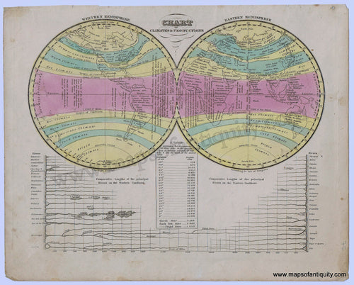
1836 - Chart of Climates & Productions, with chart of the Comparative lengths of Rivers - Antique Map
![Antique-Hand-Colored-Map-Chart-of-Climates-&-Productionswith-chart-of-the-Comparative-lengths-of-Rivers-1844-Robinson-/-Olney-1800s-19th-century-Maps-of-Antiquity]()
- Regular price
- $85.00
- Sale price
- $85.00
- Regular price
-
- Unit price
- per
Sold out -
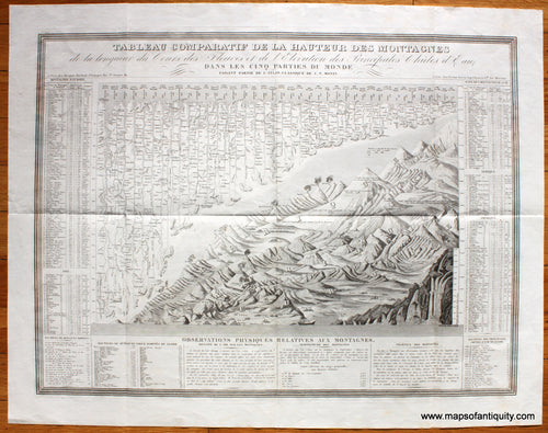
1839 - Tableau Comparatif de la Hauteur des Montagnes de la longueur du Cours des Fleuves et de l'Elevation des Principals Chutes d'Eau Dans Les Cinq Parties du Monde - Antique Map
![Antique-Map-Tableau-Comparatif-de-la-Hauteur-des-Montagnes-de-la-longueur-du-Cours-des-Fleuves-et-de-l'Elevation-des-Principals-Chutes-d'Eau-Dans-Les-Cinq-Partie-du-Monde-Comparative-Table-of-the-Height-of-the-Mountains-of-the-length-of-the-Course-of-the-Rivers-and-the-Elevation-of-the-Principals-Waterfalls-in-the-Five-Parts-of-the-World-Monin-1839-1830s-1800s-Early-Mid-19th-Century-Maps-of-Antiquity]()
- Regular price
- $275.00
- Sale price
- $275.00
- Regular price
-
- Unit price
- per
Sold out -
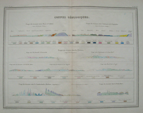
1842 - Coupes geologiques. (Carte de grandeur double). - Antique Map
![Antique-Hand-Colored-Map-Coupes-geologiques.-(Carte-de-grandeur-double).-Comparative--1842-Malte-Brun-Maps-Of-Antiquity]()
- Regular price
- $50.00
- Sale price
- $50.00
- Regular price
-
- Unit price
- per
Sold out -
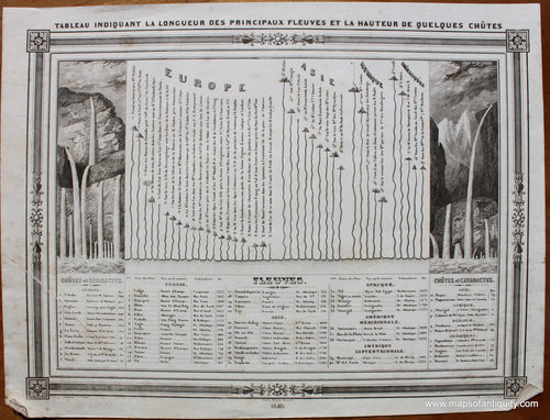
1846 - Comparative Lengths of Rivers and Heights of Waterfalls, Tableau indiquant la Longueur des Principaux Fleuves et la Hauteur de Quelques Chutes - Antique Map
![Uncolored-Antique-Comparative-Map-Comparative-Lengths-of-Rivers-and-Heights-of-Waterfalls-Tableau-indiquant-la-Longueur-des-Principaux-Fleuves-et-la-Hauteur-de-Quelques-Chutes-Comparative--1846-Barbie-du-Bocage-Maps-Of-Antiquity]()
- Regular price
- $115.00
- Sale price
- $115.00
- Regular price
-
- Unit price
- per
Sold out -
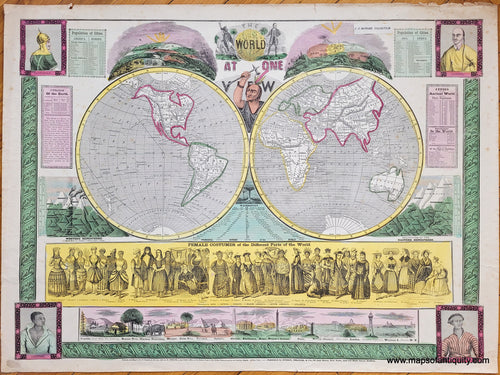
1847 - The World at One View - Antique Map
![Vibrantly colored antique map of the world with numerous illustrations and diagrams around it. This map, in colors of green, yellow, pink, and blue, was published and hand-colored in 1847 by Ensign, Thayer, and Phelps.]()
- Regular price
- $1,100.00
- Sale price
- $1,100.00
- Regular price
-
- Unit price
- per
Sold out -
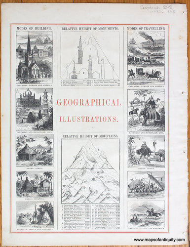
1848 - Geographical Illustrations - Antique Print
![Genuine-Antique-Print-Geographical-Illustrations-1848-Goodrich-Maps-Of-Antiquity-1800s-19th-century]()
- Regular price
- $45.00
- Sale price
- $45.00
- Regular price
-
- Unit price
- per
Sold out -
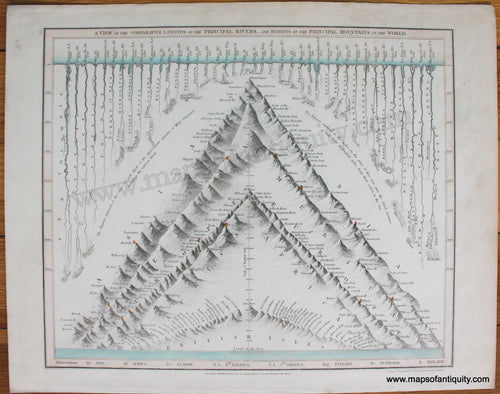
1849 - A View of the Comparative Lengths of the Principal Rivers, and Heights of the Principal Mountains of the World - Antique Chart
![Antique-Map-comparative-Lengths-Rivers-Heights-Mountains-Orr-Company-Dower-1850-1850s-1800s-19th-century-Maps-of-Antiquity]()
- Regular price
- $175.00
- Sale price
- $175.00
- Regular price
-
- Unit price
- per
Sold out -
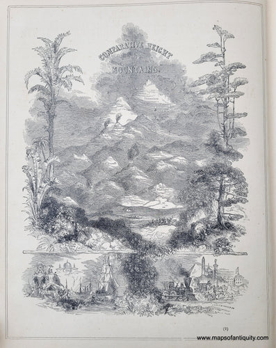
1850 - Comparative Heights of Mountains - Antique Map
![Genuine-Antique-Print-Comparative-Heights-of-Mountains-1850-Mitchell-Thomas-Cowperthwait-Co--Maps-Of-Antiquity]()
- Regular price
- $55.00
- Sale price
- $55.00
- Regular price
-
- Unit price
- per
Sold out -
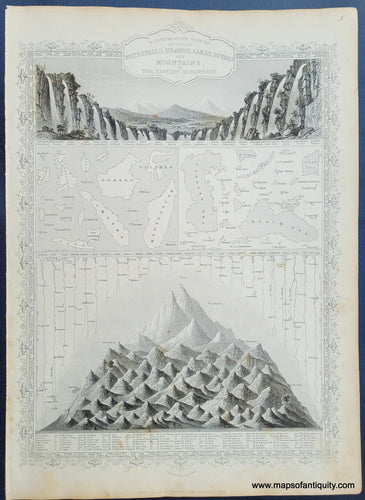
1851 - A Comparative View of the Principal Waterfalls, Islands, Lakes, Rivers and Mountains of the Eastern Hemisphere. - Antique Map
![Antique-Hand-Colored-Map-A-Comparative-View-of-the-Principal-Waterfalls-Islands-Lakes-Rivers-and-Mountains-of-the-Eastern-Hemisphere.--Comparative-Maps--1851-Tallis-Maps-Of-Antiquity]()
- Regular price
- $150.00
- Sale price
- $150.00
- Regular price
-
- Unit price
- per
Sold out -
1855 - Botanical Profile representing the Forest Trees along the Route explored by Lieut. A. W. Whipple… from Fort Smith to San Pedro - Antique Map
![Genuine-Antique-Survey-Map-Botanical-Profile-representing-the-Forest-Trees-along-the-Route-explored-by-Lieut-A-W-Whipple…-near-the-Parallel-of-35-degrees-North-Latitude-1853-1854-from-Fort-Smith-to-San-Pedro-1855-Bigelow-Wagner---McGuigan-Maps-Of-Antiquity]()

- Regular price
- $300.00
- Sale price
- $300.00
- Regular price
-
- Unit price
- per
Sold out -
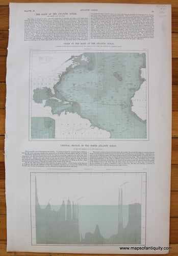
1856 - Chart of the Basin of the Atlantic Ocean; Vertical Section of the North Atlantic Ocean - Antique Map
![Chart-of-the-Basin-of-the-Atlantic-Ocean-Vertical-Section-of-the-North-Atlantic-Ocean-Johnston-1856-Antique-Map-1850s-1800s]()
- Regular price
- $75.00
- Sale price
- $75.00
- Regular price
-
- Unit price
- per
Sold out -
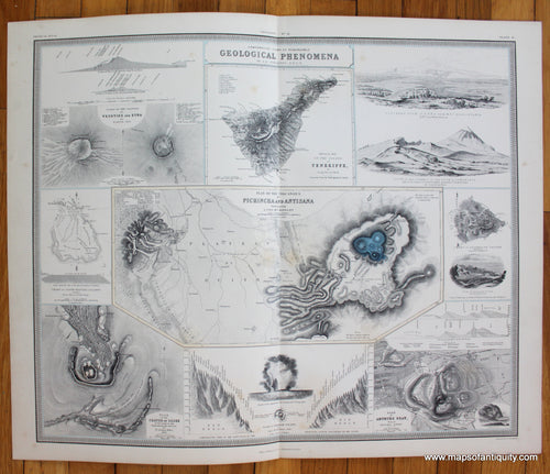
1856 - Comparative Views of Remarkable Geological Phenomena - Antique Map
![Comparative-Views-of-Remarkable-Geological-Phenomena-Johnston-1856-Antique-Map-1850s-1800s]()
- Regular price
- $175.00
- Sale price
- $175.00
- Regular price
-
- Unit price
- per
Sold out -
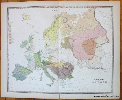
1856 - Ethnographic Map of Europe. - Antique Map
![Ethnographic-Map-of-Europe-Johnston-1856-Antique-Map-1850s-1800s]()
- Regular price
- $175.00
- Sale price
- $175.00
- Regular price
-
- Unit price
- per
Sold out -
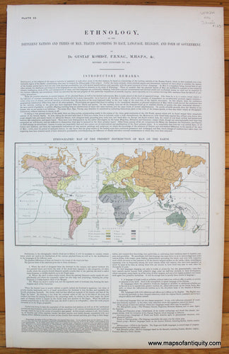
1856 - Ethnographic Map of the Present Distribution of Man on the Earth - Antique Map
![Ethnographic-Map-of-the-Present-Distribution-of-Man-on-the-Earth-Johnston-1856-Antique-Map-1850s-1800s]()
- Regular price
- $125.00
- Sale price
- $125.00
- Regular price
-
- Unit price
- per
Sold out -
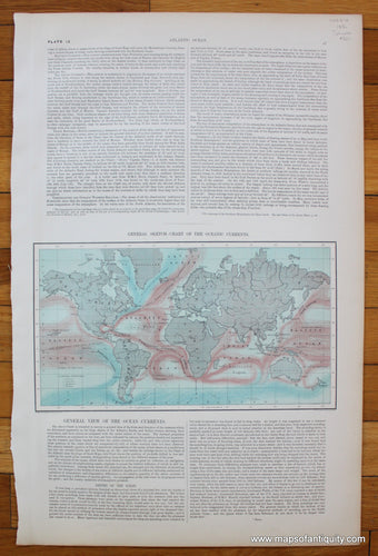
1856 - General Sketch Chart of the Oceanic Currents, verso Map of the Arctic Basin - Antique Map
![General-Sketch-Chart-of-the-Oceanic-Currents-verso-Map-of-the-Arctic-Basin-Johnston-1856-Antique-Map-1850s-1800s]()
- Regular price
- $50.00
- Sale price
- $50.00
- Regular price
-
- Unit price
- per
Sold out -
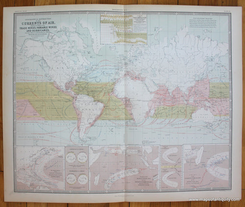
1856 - Geographical Distribution of the Currents of the Air, Showing the Regions of the Trade Winds, Variable Winds, and Hurricanes, with their effects in determining the different Tracks of Navigation. - Antique Map
![Geographical-Distribution-of-the-Currents-of-the-Air-Johnston-1856-Antique-Map-1850s-1800s]()
- Regular price
- $125.00
- Sale price
- $125.00
- Regular price
-
- Unit price
- per
Sold out -
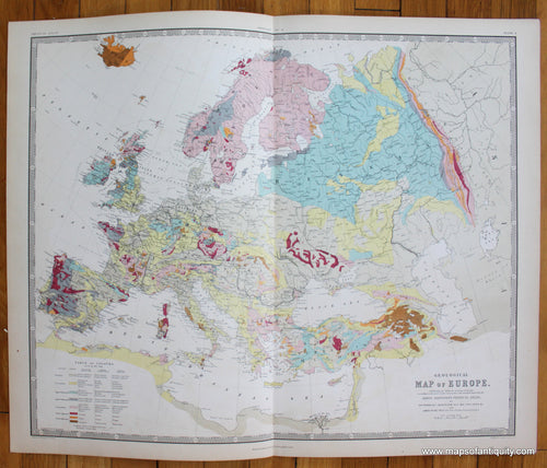
1856 - Geological Map of Europe, Exhibiting the different systems of Rocks according to the most recent researches and unedited materials... - Antique Map
![Geological-Map-Europe-Johnston-1856-Antique-Map-1850s-1800s]()
- Regular price
- $175.00
- Sale price
- $175.00
- Regular price
-
- Unit price
- per
Sold out -
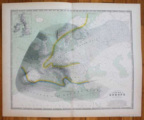
1856 - Hyetographic or Rain Map of Europe. - Antique Map
![Hyetographic-Rain-Rainfall-Map-of-Europe-Johnston-1856-Antique-Map-1850s-1800s]()
- Regular price
- $75.00
- Sale price
- $75.00
- Regular price
-
- Unit price
- per
Sold out -
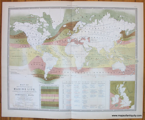
1856 - Map of the Distribution of Marine Life. - Antique Map
![Geographical-Distribution-of-Marine-Life-Johnston-1856-Antique-Map-1850s-1800s]()
- Regular price
- $175.00
- Sale price
- $175.00
- Regular price
-
- Unit price
- per
Sold out -
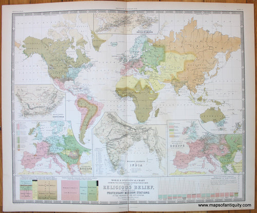
1856 - Moral and Statistical Chart of the Distribution of Man. - Antique Map
![Moral-and-Statistical-Chart-of-the-Distribution-of-Man-Johnston-1856-Antique-Map-1850s-1800s]()
- Regular price
- $175.00
- Sale price
- $175.00
- Regular price
-
- Unit price
- per
Sold out -
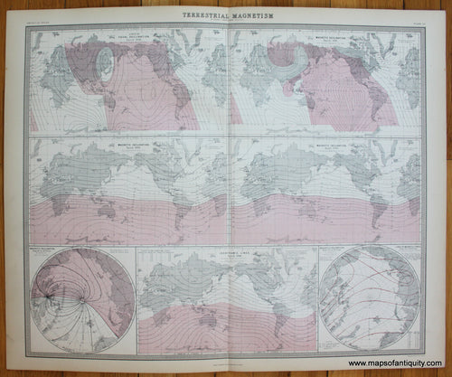
1856 - Terrestrial Magnetism. - Antique Map
![Terrestrial-Magnetism-Johnston-1856-Antique-Map-1850s-1800s]()
- Regular price
- $150.00
- Sale price
- $150.00
- Regular price
-
- Unit price
- per
Sold out -
1856 - The Mountain Systems of Europe - Antique Map
![Mountain-Systems-Map-Europe-Johnston-1856-Antique-Map-1850s-1800s]()

- Regular price
- $125.00
- Sale price
- $125.00
- Regular price
-
- Unit price
- per
Sold out -
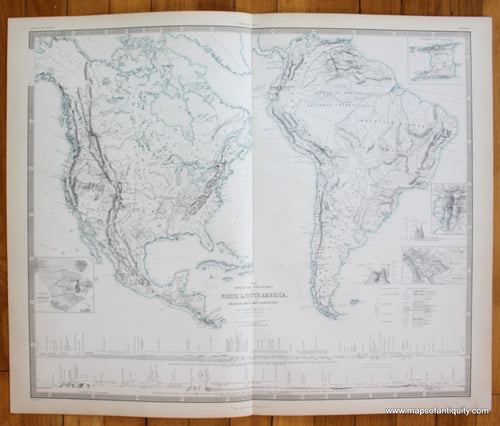
1856 - The Physical Features of North and South America. - Antique Map
![The-Physical-Features-of-North-and-South-America-Johnston-1856-Antique-Map-1850s-1800s]()
- Regular price
- $150.00
- Sale price
- $150.00
- Regular price
-
- Unit price
- per
Sold out -
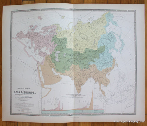
1856 - The River Systems of Asia & Europe. - Antique Map
![The-River-Systems-of-Europe-Asia-Johnston-1856-Antique-Map-1850s-1800s]()
- Regular price
- $125.00
- Sale price
- $125.00
- Regular price
-
- Unit price
- per
Sold out -
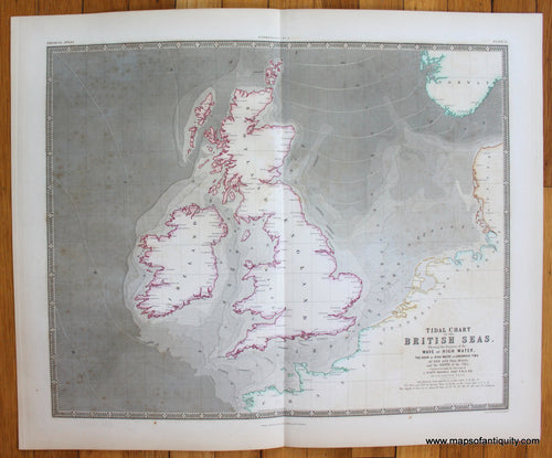
1856 - Tidal Chart of the British Seas. - Antique Map
![Tidal-Chart-British-Seas-England-Scotland-Wales-Map-of-Great-Britain-and-Ireland-Johnston-1856-Antique-Map-1850s-1800s]()
- Regular price
- $50.00
- Sale price
- $50.00
- Regular price
-
- Unit price
- per
Sold out -
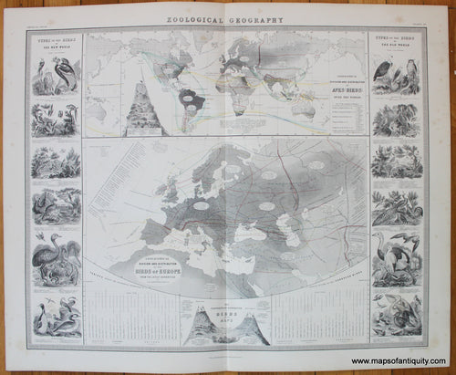
1856 - Zoological Geography: Geographical Distribution of Aves (Birds). - Antique Map
![Geographical-Distribution-of-Aves-Johnston-1856-Antique-Map-1850s-1800s]()
- Regular price
- $150.00
- Sale price
- $150.00
- Regular price
-
- Unit price
- per
Sold out


- Page 1 of 4
- Next page