Collection: Midwest US General - Antique
-
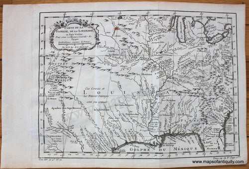
1757 - Carte de la Floride, de la Louisiane, et Pays Voisins. - Antique Map
![Antique-Uncolored-Map-Carte-de-la-Floride-de-la-Louisiane-et-Pays-Voisins.--United-States-South-1757-Bellin-Maps-Of-Antiquity]()
- Regular price
- $375.00
- Sale price
- $375.00
- Regular price
-
- Unit price
- per
Sold out -
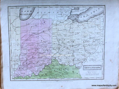
1830 - Ohio & Indiana - Antique Map
![Genuine-Antique-Map-Ohio-&-Indiana-1830-E.-Huntington-/-D.F.-Robinson-&-Co.-Maps-Of-Antiquity]()
- Regular price
- $115.00
- Sale price
- $115.00
- Regular price
-
- Unit price
- per
Sold out -
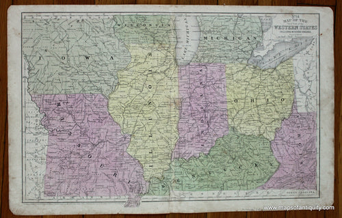
1839 - Map of the Western States [Midwest] - Antique Map
![Genuine-Antique-Map-Map-of-the-Western-States-[Midwest]-1839-Smith-Paine-Burgess-Maps-Of-Antiquity]()
![Genuine-Antique-Map-Map-of-the-Western-States-[Midwest]-1839-Smith-Paine-Burgess-Maps-Of-Antiquity](//mapsofantiquity.com/cdn/shop/files/MWE588-Genuine-Antique-Map-Map-of-the-Western-States-Midwest-1839-Smith-Paine-Burgess-Maps-Of-Antiquity_809f8838-974e-4567-9df1-d48f17775165_250x250@2x.jpg?v=1715464009)
- Regular price
- $65.00
- Sale price
- $65.00
- Regular price
-
- Unit price
- per
Sold out -
1839 - Midwest - No. 9 Map of the Chief Part of the Western States - Antique Map
![]()

- Regular price
- $110.00
- Sale price
- $110.00
- Regular price
-
- Unit price
- per
Sold out -
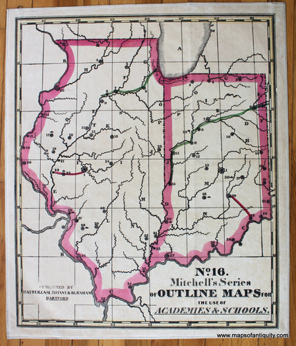
1841 - No. 16. Mitchell's Series of Outline Maps for the use of Academies & Schools. Illinois and Indiana - Antique Map
![Antique-Hand-Colored-School-Map-No.-16.-Mitchell's-Series-of-Outline-Maps-for-the-use-of-Academies-&-Schools.-Illinois-and-Indiana--United-States-Midwest-1841-Mitchell-Maps-Of-Antiquity]()
- Regular price
- $250.00
- Sale price
- $250.00
- Regular price
-
- Unit price
- per
Sold out -
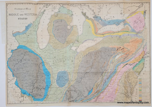
1843 - Geological Map of the Middle and Western States - Antique Map
![Genuine-Antique-Geological-Map-Geological-Map-of-the-Middle-and-Western-States-1843-James-Hall-Maps-Of-Antiquity]()
- Regular price
- $850.00
- Sale price
- $850.00
- Regular price
-
- Unit price
- per
Sold out -
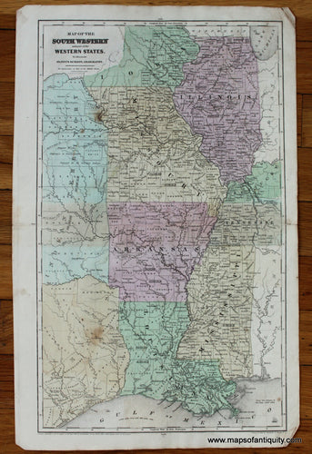
1844 - Map of the South Western and part of the Western States - Antique Map
![Antique-Hand-Colored-Map-Map-of-the-South-Western-and-part-of-the-Western-States-United-States-Midwest-1844-Robinson-Maps-Of-Antiquity]()
- Regular price
- $175.00
- Sale price
- $175.00
- Regular price
-
- Unit price
- per
Sold out -
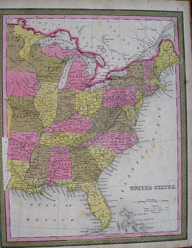
1846 - United States. - Antique Map
![Antique-Hand-Colored-Map-United-States.--United-States-Eastern-United-States-1846-H.N.-Burroughs-from-Mitchell-Universal-Atlas-Maps-Of-Antiquity]()
- Regular price
- $195.00
- Sale price
- $195.00
- Regular price
-
- Unit price
- per
Sold out -
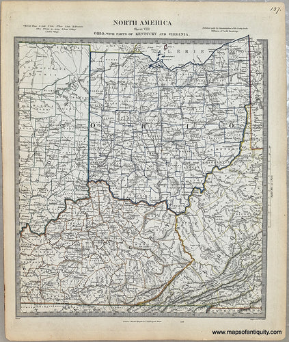
1850 - North America Sheet VIII Ohio, with parts of Kentucky and Virginia. - Antique Map
![Antique-Map-North-America-Sheet-VIII-Ohio-with-parts-of-Kentucky-and-Virginia]()
- Regular price
- $75.00
- Sale price
- $75.00
- Regular price
-
- Unit price
- per
Sold out -
1854 - Midwest - No. 14 Map of the Chief Part of the Western States Including Western Virginia - Antique Map
![Antique-Hand-Colored-Map-No.-14-Map-of-the-Chief-Part-of-the-Western-States-Including-Western-Virginia-United-States-Midwest-1854-Mitchell-Maps-Of-Antiquity]()
- Regular price
- $75.00
- Sale price
- $75.00
- Regular price
-
- Unit price
- per
Sold out -
1855 - Iowa - Antique Map
![Antique-Hand-Colored-Map-Iowa--United-States-Iowa-1855-Colton-Maps-Of-Antiquity]()
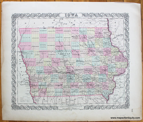
- Regular price
- $125.00
- Sale price
- $125.00
- Regular price
-
- Unit price
- per
Sold out -
1856 - Guide through Ohio, Michigan, Indiana, Illinois, Missouri, Wisconsin, Iowa, Minnesota, Nebraska and Kansas. - Antique Map
![Antique-Hand-Colored-Map-Guide-through-Ohio-Michigan-Indiana-Illinois-Missouri-Wisconsin-Iowa-Minnesota-Nebraska-and-Kansas.-Showing-the-Township-lines-of-the-United-States-Surveys-Location-of-Cities-Towns-Villages-Post-Hamlets-Canals-Rail-and-Stage-Roads.-Midwest-General--1856-Smith-Maps-Of-Antiquity]()
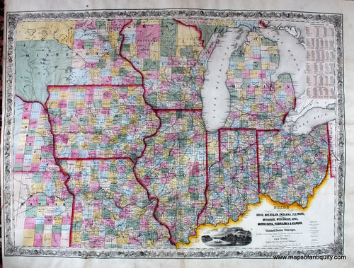
- Regular price
- $675.00
- Sale price
- $675.00
- Regular price
-
- Unit price
- per
Sold out -
1859 - Northern United States, North Central Sheet - Antique Map
![Antique-Map-United-States-North-Midwest-1859]()
- Regular price
- $95.00
- Sale price
- $95.00
- Regular price
-
- Unit price
- per
Sold out -
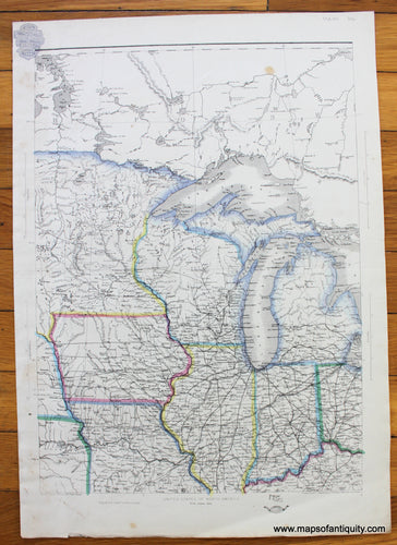
1860 - North America (Sheet IX) Parts of Missouri, Illinois, Iowa & Indiana - Antique Map
![Antique-Map-North-America-Sheet-IX-Missouri-Illinois-Iowa-Indiana-United-States-Midwest-Midwestern-U.S.-US-SDUK-S.D.U.K.-Society-for-the-Diffusion-of-Useful-Knownledge-1860s-1800s-Mid-Late-19th-Century-Maps-of-Antiquity]()
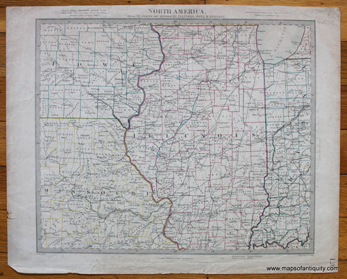
- Regular price
- $55.00
- Sale price
- $55.00
- Regular price
-
- Unit price
- per
Sold out -
1863 - Northern United States, North West Sheet - Antique Map
![Antique-Hand-Colored-Map-Northern-United-States-North-West-Sheet-United-States-West-1863-Ettling-Maps-Of-Antiquity]()
- Regular price
- $150.00
- Sale price
- $150.00
- Regular price
-
- Unit price
- per
Sold out -
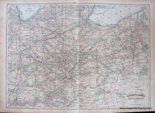
1872 - Ohio & Indiana. - Antique Map
![Antique-Map-Ohio-&-Indiana]()
- Regular price
- $75.00
- Sale price
- $75.00
- Regular price
-
- Unit price
- per
Sold out -
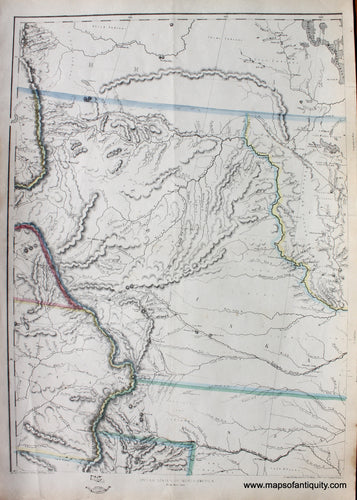
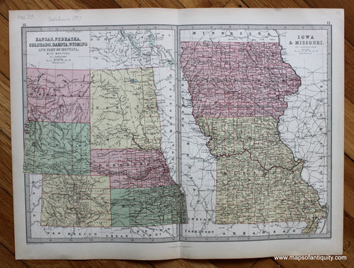
1873 - Kansas, Nebraska, Colorado, Dakota, Wyoming and Part of Montana, with Manitoba. Iowa & Missouri. - Antique Map
![Antique-Printed-Color-Map-Kansas-Nebraska-Colorado-Dakota-Wyoming-and-Part-of-Montana-with-Manitoba.-Iowa-&-Missouri.-United-States-Midwest-1873-J.-Bartholomew-Maps-Of-Antiquity]()
- Regular price
- $75.00
- Sale price
- $75.00
- Regular price
-
- Unit price
- per
Sold out -
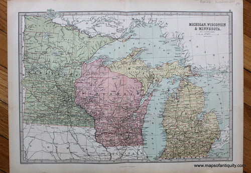
1873 - Michigan, Wisconsin & Minnesota - Antique Map
![Antique-Printed-Color-Map-Michigan-Wisconsin-&-Minnesota-United-States-Midwest-1873-J.-Bartholomew-Maps-Of-Antiquity]()
- Regular price
- $90.00
- Sale price
- $90.00
- Regular price
-
- Unit price
- per
Sold out -
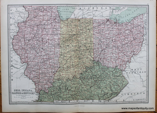
1873 - Ohio, Indiana, Illinois & Kentucky - Antique Map
![Antique-Printed-Color-Map-Ohio-Indiana-Illinois-&-Kentucky-United-States-Midwest-1873-J.-Bartholomew-Maps-Of-Antiquity]()
- Regular price
- $90.00
- Sale price
- $90.00
- Regular price
-
- Unit price
- per
Sold out -
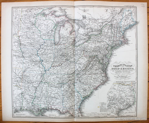
1876 - Eastern United States - Verein-Staaten von Nord-America mit Ausnahme Florida's und der westlichen Territorien - Antique Map
![Antique-Map-Verein-Staaten-Nord-America-Eastern-United-States-US-USA-Stieler-1876-1870s-1800s-19th-century-Maps-of-Antiquity]()
- Regular price
- $85.00
- Sale price
- $85.00
- Regular price
-
- Unit price
- per
Sold out -
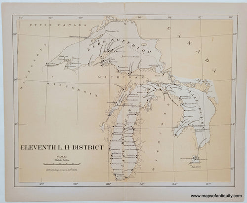
1881 - Lighthouses of Lake Superior, Lake Huron, and Lake Michigan - Antique Map
![Antique-Map-chart-Lighthouses-Great-lakes-Lake-Superior-Lake-Huron-Lake-Michigan-1881-USLHS-1880s-19th-century]()
- Regular price
- $100.00
- Sale price
- $100.00
- Regular price
-
- Unit price
- per
Sold out -
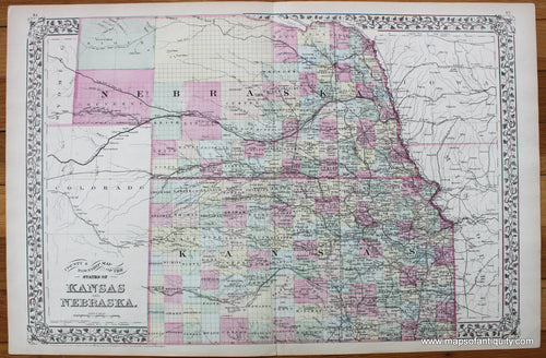
1883 - County & Township Map of the States of Kansas and Nebraska. - Antique Map
![Antique-Hand-Colored-Map-County-&-Township-Map-of-the-States-of-Kansas-and-Nebraska.-United-States-Mid-west-1883-Mitchell-Maps-Of-Antiquity]()
- Regular price
- $85.00
- Sale price
- $85.00
- Regular price
-
- Unit price
- per
Sold out -
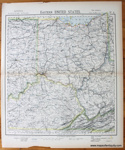
1883 - Eastern United States, Sheet Five of Ten - Antique Map
![printed-color-Antique-Map-Eastern-United-States-Sheet-Five-of-Ten-United-States-Midwest-1883-Letts-Maps-Of-Antiquity]()

- Regular price
- $75.00
- Sale price
- $75.00
- Regular price
-
- Unit price
- per
Sold out -
1883 - Eastern United States, Sheet Four of Ten - Antique Map
![printed-color-Antique-Map-Eastern-United-States-Sheet-Four-of-Ten-United-States-Midwest-1883-Letts-Maps-Of-Antiquity]()
- Regular price
- $75.00
- Sale price
- $75.00
- Regular price
-
- Unit price
- per
Sold out -
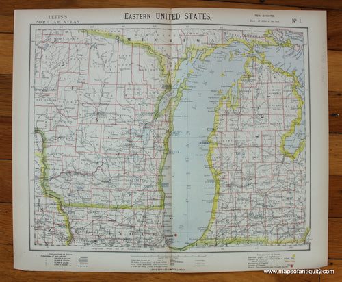
1883 - Eastern United States, Sheet One of Ten - Antique Map
![printed-color-Antique-Map-Eastern-United-States-Sheet-One-of-Ten-North-America-Northeast-1883-Letts-Maps-Of-Antiquity]()
- Regular price
- $75.00
- Sale price
- $75.00
- Regular price
-
- Unit price
- per
Sold out -
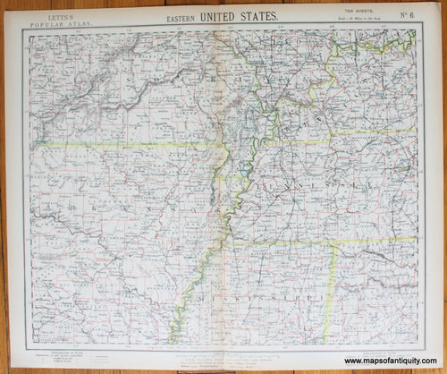
1883 - Eastern United States, Sheet Six of Ten - Antique Map
![printed-color-Antique-Map-Eastern-United-States-Sheet-Six-of-Ten-United-States-Midwest-1883-Letts-Maps-Of-Antiquity]()
- Regular price
- $75.00
- Sale price
- $75.00
- Regular price
-
- Unit price
- per
Sold out -
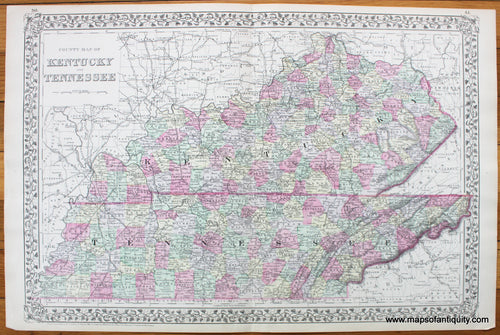
1884 - County Map of Kentucky and Tennessee - Antique Map
![Antique-Hand-Colored-Map-County-Map-of-Kentucky-and-Tennessee-United-States-Mid-west-1884-Mitchell-Maps-Of-Antiquity]()
- Regular price
- $95.00
- Sale price
- $95.00
- Regular price
-
- Unit price
- per
Sold out -
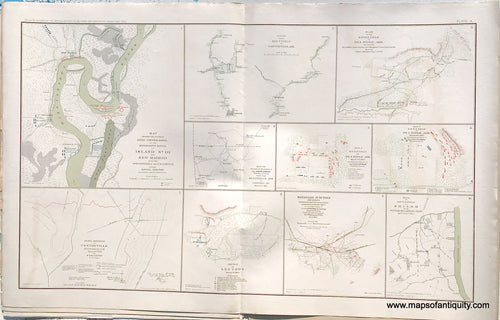
1891 - Plate 10. Rebel Fortifications on Mississippi River at Island No. 10 and New Madrid / Rebel Position at Centreville, March 14th, 1862 plus 8 smaller maps - Antique Print
![Antique-Lithograph-Print-Plate-10.-Rebel-Fortifications-on-Mississippi-River-at-Island-No.-10-and-New-Madrid-/-Rebel-Position-at-Centreville-March-14th-1862-plus-8-smaller-maps-1891-US-War-Dept.-Civil-War-Civil-War-1800s-19th-century-Maps-of-Antiquity]()
- Regular price
- $75.00
- Sale price
- $75.00
- Regular price
-
- Unit price
- per
Sold out -
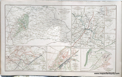
1892 - Plate 45. Orange County &c. VA. / Military Departments of Washington, Pennsylvania, Annapolis and Northeastern Virginia, July, 1861 / Map to show Lines of March of Second Army Corps and The Enemy, & more (see description) - Antique Print
![Antique-Lithograph-Print-Plate-45.-Orange-County-&c.-VA.-/-Military-Departments-of-Washington-Pennsylvania-Annapolis-and-Northeastern-Virginia-July-1861-/-Map-to-show-Lines-of-March-of-Second-Army-Corps-and-The-Enemy--Battle-Field-at-Bristoe-Missionary-Ridge-Tenn.-1892-US-War-Dept.-Civil-War-Civil-War-1800s-19th-century-Maps-of-Antiquity]()
- Regular price
- $95.00
- Sale price
- $95.00
- Regular price
-
- Unit price
- per
Sold out -
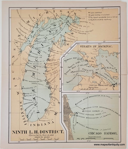
1893 - Lighthouses of Lake Michigan - Antique Map
![NAU247-Ninth-L.-H.-DIstrict-Lake-Michigan-Great-Lakes-Lighthouse-Chart-Antique.-DIstrict-Lake-Michigan-Chicago-Straits of Mackinac-Great-Lakes-Lighthouse-Chart-1893]()
- Regular price
- $115.00
- Sale price
- $115.00
- Regular price
-
- Unit price
- per
Sold out -
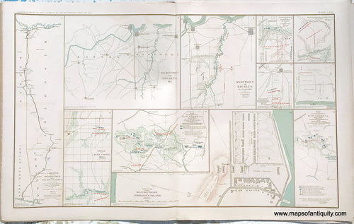
1893 - Plate 66. Campaign against Sterling Price, 1864 / West Point and Big Blue, Mo. / West Point and Big Blue, October 22nd and 23rd, 1864 / Battle-Field of Five Forks, Va. & more (see description) - Antique Print
![Antique-Lithograph-Print-Plate-66.-Campaign-against-Sterling-Price-1864-/-West-Point-and-Big-Blue-Mo.-/-West-Point-and-Big-Blue-Battle-Field-of-Five-Forks-Va.-Battle-Field-of-Five-Forks-Va.-April-1st-1865-showing-positions-and-movements-/-Military-Prison-on-Johnson's-Island-Ohio-/-plus-6-smaller-maps.-1893-US-War-Dept.-Civil-War-Civil-War-1800s-19th-century-Maps-of-Antiquity]()
- Regular price
- $75.00
- Sale price
- $75.00
- Regular price
-
- Unit price
- per
Sold out -
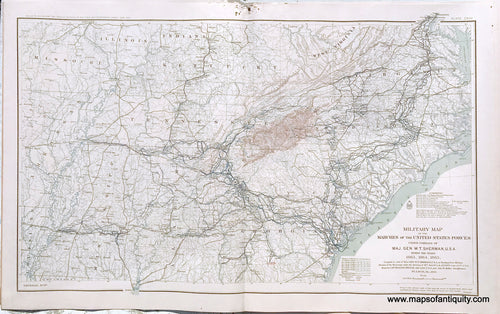
1894 - Plate 117. Military map of the Marches of the United State Forces under command of Major Gen. W.T. Sherman during the years 1863, 1864 and 1865. - Antique Print
![Antique-Lithograph-Print-Plate-117.-Military-map-of-the-Marches-of-the-United-State-Forces-under-command-of-Major-Gen.-W.T.-Sherman-during-the-years-1863-1864-and-1865.-1894-US-War-Dept.-Civil-War-Civil-War-1800s-19th-century-Maps-of-Antiquity]()
- Regular price
- $250.00
- Sale price
- $250.00
- Regular price
-
- Unit price
- per
Sold out


![Genuine-Antique-Map-Map-of-the-Western-States-[Midwest]-1839-Smith-Paine-Burgess-Maps-Of-Antiquity](http://mapsofantiquity.com/cdn/shop/files/MWE588-Genuine-Antique-Map-Map-of-the-Western-States-Midwest-1839-Smith-Paine-Burgess-Maps-Of-Antiquity_809f8838-974e-4567-9df1-d48f17775165_{width}x.jpg?v=1715464009)
![Genuine-Antique-Map-Map-of-the-Western-States-[Midwest]-1839-Smith-Paine-Burgess-Maps-Of-Antiquity](http://mapsofantiquity.com/cdn/shop/files/MWE588-Genuine-Antique-Map-Map-of-the-Western-States-Midwest-1839-Smith-Paine-Burgess-Maps-Of-Antiquity_809f8838-974e-4567-9df1-d48f17775165_250x250@2x.jpg?v=1715464009)


- Page 1 of 3
- Next page